Thursday, July 16, 2015

Nakupoo...The Sicapoo Adventure!

When asked of one of the most difficult climbs in the Philippines, Mt. Sicapoo would definitely be included in the top 5. Here's why.
First, river crossing. I lost count on how many times we've crossed Gasgas river but luckily;  the weather was fine making the river passable enough inspite of the strong rapids tugging us along.
The unlimited river crossing at Gasgas river.
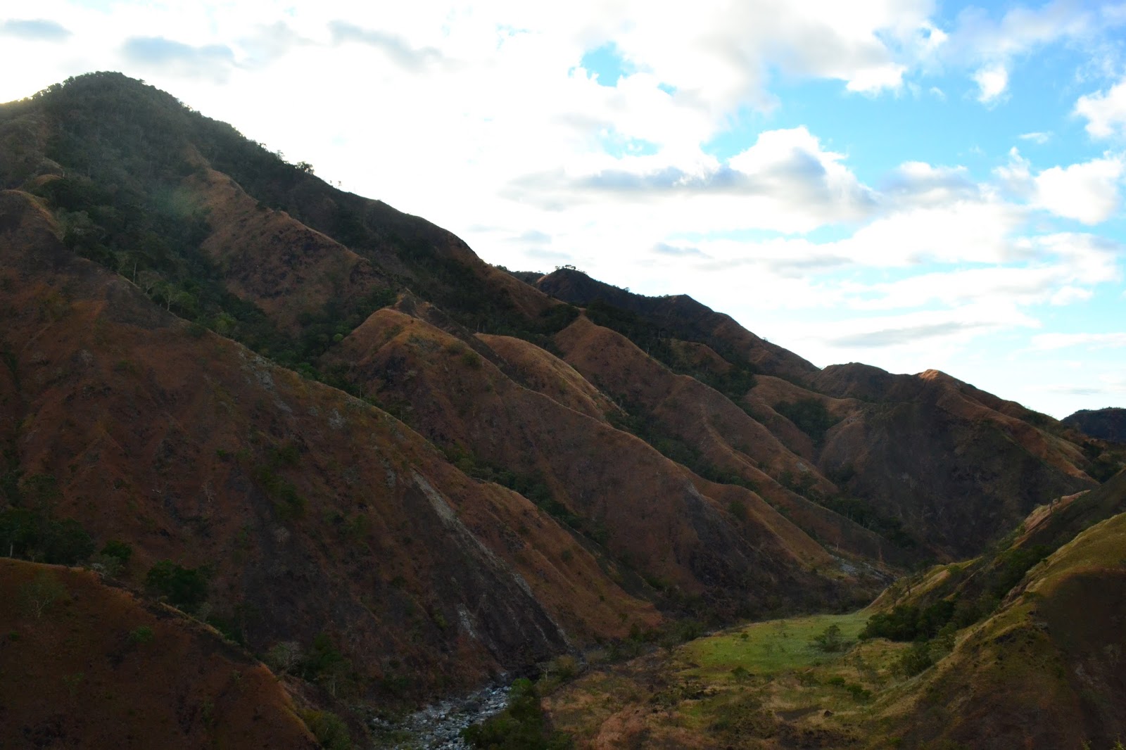
Second, loose rocks. Since we climbed on a good weather, loose rocks are more pronounced making it harder to put weight on every step. Scarier on my part because the soles of my shoes are almost worn off.
The nonstop loose rocks on both ascent and descent.
Third, steep ridges. If ascending a steep ridge is hard, try going down. I don't remember which one was harder though, focusing on my steps or admiring the beautiful yet dangerous ridges.
Sweet torture! More ridges,  baby!
Fourth, strong winds. If ridges are hard enough to cross, try adding some strong winds. You get the picture.
These windy portion of the ridges was just scary.
Lastly, it's a traverse! Some said there are total of 9 peaks (including Sicapoo's summit) on the entire climb. Towering at 2,354+ MASL, Mt. Sicapoo is a sight to behold. The kilometer read on a friend's watch was roughly around 43 km. Other said it was more than 43 km. Needless to say, it was long.
Mt. Sicapoo seen at  Mt. Timarid and me with the 'Penguin'
The windy ridges before the plateau.
Below itinerary based on my personal experience.
Day 0
2100 Meet up at Florida Bus Lines (Manila)
2130 ETD Manila to Laoag
Day 1
0620 ETA Laoag. Breakfast at carinderia.
0700 ETD Laoag to Solsona via chartered jeep.
0810 ETA Solsona Public Market. Buy supplies and packed lunch.
0900 ETA Solsona Municipal Police station. Register.
0920 ETA Brgy. Manalpac (jumpoff). Register. Meet guides. Final preparation before start of climb.
1020 Start trek to Gasgas river.
1100 ETA Gasgas river (first river crossing).  Take 5.
1230 ETA third river crossing. Lunch.
1300 Resume trek.
1420 ETA last river crossing. Rest. Swim.
1600 Resume trek. Start of assault climb.
2000 ETA Saulay campsite. Setup camp.
2100 Dinner. Socials.
2200 Lights off.
Day 2
0400 Wakeup call
0500 Breakfast. Prepare assault pack.
0545 Start trek to Mt. Sicapoo summit.
0800 ETA Pakpako campsite.
1015 ETA Mt. Matalidong peak (2100+ MASL). Rest and photo opt.
1040 Resume trek.
1120 ETA Mt.  Sicapoo summit. Photo opt with the 'Penguin Rock' formation. Lunch.
1210 ETD Mt. Sicapoo summit back to Saulay campsite.
1410 ETA Pakpako campsite.
1620 ETA Saulay campsite.
1800 Early dinner. Prepare packed lunch for Day 3.
2000 Lights off.
Day 3
0530 Wakeup call
0630 Breakfast. Break camp.
0800 Start trek to Mt. Timarid.
1050 ETA Mt. Timarid (1,527 MASL)
1150 ETA Mt. Simagaysay (1,341 MASL). Lunch.
1300 Start of series of ridges. Windy part.
1550 ETA One degree plateau. Rest.
1600 Resume trek.
1615 End of plateau.
1626 ETA Solsona Dam.
1720 Wash up at guide's house.
1900 ETD to Laoag.
2020 Post climb dinner.
2115 ETD Laoag to Manila.
View of mountain ranges from Balbalitok peak
Top: one degree plateau; bottom: Solsona Dam
Writing this article was easy but as they say, nothing compares to the feeling of accomplishing a tough mountain (rated 9/9 on difficulty level) that offers not only pain and sweet torture but an astounding showcase of nature's beauty and magnificence.
Scenic view during my Sicapoo traverse adventure.
Climb while you can. The mountains are calling.

Till then.


Wednesday, July 15, 2015

Kalinga and Whang Od - A Moment to Remember

I got my first tattoo back in 2011. Eversince then, it was a dream of mine that one day I'd be able to meet Buscalan's very own - Whang Od.
Whang Od and the blogger
I don't want to bore you with loads of background introduction of this famous traditional tattooist (well, that's me lacking energy searching the net for her biography). Mainly; she's 96 years old, healthy as a horse, came from Butbut tribe and up to this day is still practicing the art of traditional tattoing called 'batok'.
Drop off point going to Tinglayan then Buscalan.
A rainy atmosphere greeted us on our way to Buscalan but that didn't stop us from enjoying the view of the small town where I'll be having my next ink (8th and 9th, respectively) and a first to the 9 brave fellows who was with me during that time.
Drop off point to Buscalan.
The 30-minute walk to Brgy. Buscalan
Walkway signage at Brgy.  Buscalan
Here we come!
Meeting Whang Od for the first time was as normal as seeing your own grandmother. She was warm and so are the people of Buscalan (contrary to their past and rich culture of being warriors and headhunters); but don't be misled by her fragile and petite appearance because she's tough (boy, she can hit that 'siit' <thorn used to put ink> hard)!
Grace and the blogger.
Sweet goodies for Buscalan kids.
After settling our stuff at Grace's house (Whang Od's grandniece and apprentice) and sipping the last drop of freshly brewed coffee offered by Grace herself, we head back to pick our tattoo design from the three magazines presented to us. Well,  you know the rest.
That is pain personified! 
My friends' first ink
Another set of traditional 'batok' designs.
Whang Od's masterpiece on my skin, the Scorpio. 
Below is the itinerary for your reference.
Day 0
2000 ETD Victory liner Kamuning (bus fare - 700)
Day 1
0210 Stopover at nueva vizcaya
0700 ETA Tabuk
0825 ETD Tabuk to Tinglayan (chartered jeep)
1050 ETA Tinglayan
1200 ETD Bugnay to Buscalan (van ride)
1400 ETA Buscalan.
1500 Start tattoo session
Day 2
0530 Wake up call                
0630 Breakfast                      
0700 Resume tattoo session
1030 ETD Buscalan    
1100 ETA Buscalan jumpoff. Wait for van.
1145 ETD Buscalan to Bontoc via chartered van  
1420 ETD Bontoc to Baguio
2030 ETA Baguio. Dinner.
1000 ETD Baguio to Manila via Dagupan bus (bus fare - 445)
Day 3
0330 ETA Cubao

Don't forget to drop me a message for any inquiries. I'll be happy to help!
Till then!

Thursday, February 19, 2015

My Favorite Climb - Pantingan Peak

It was almost a month since my last article and today, I bring you my top favorite climb (for now), Pantingan Peak.

Regarded as the highest peak of the crater rim of Mt. Mariveles and known to locals as Banayan Peak, this silent beauty was our main goal (5 hikers including me) to summit last January 10.

Thirty minutes before 12am of January 9 when we left the not so busy road of EDSA to Balanga. We arrived past 2 AM in Balanga and had a quick fix of 'lugaw' (rice porridge) before going to the nearby terminal.

Since we arrived early, we waited till 5 AM before jumping at the mini bus bound for Morong. After an hour, we arrived at Friendship Tower in Bagac where our pre-arranged tricycle ride awaits.
The transpo marathon
It was a short 20-minute ride but the cool breeze of the early morning was just too much. Finally, we arrived at Barangay Saysain where Sir Rey Jimenez (our guide) welcomed us.
The weekend warriors and Sir Rey's family
We left some stuff at Sir Rey's house before starting our trek at 7 AM. By 8:30 AM, we reached the grassland which locals and hikers tagged as the 'Marlboro country.' We took at least a good 15-minute rest from there while snapping pictures of the scenic beauty of the nearby beaches and mountain ranges.
Mountain ranges, the group rest and the river before grassland
An hour after that, we reached Danny's gate. Took some pics and prepared for battle with the limatiks :) True enough, sightings of limatik were experienced as we reached higher grounds. The assault came as a surpise but glad that we're inside such healthy forest that monkey trailing was an advantage.
Flora, fauna and the likes....
The saddest view along the trail.
By 11:20 AM, we reached Subangan campsite. Took another 10-minute rest while removing limatik slithering our shoes and pants. According to Sir Rey, with our pacing we can reach the summit past 12 in the afternoon.
Top pic: Danny's gate. Bottom pic: Subangan (for wild boars)
Around 12:46 when we reached Pantingan Peak. The summit was foggy, cold and covered with thick and overgrown plants and bonsai trees. Exhausted and sad that a clearing was nowhere to be found, we still congratulated one another as we ate our lunch and threw banters (not to mention removing limatiks from time to time...yup, they're at the summit as well)
while waiting for the clearing....
But luck of all luck, we heard Sir Rey shouting at us on the other side...'Bumubuka na!' (It's opening... referring to the clearing.)
'Groupie' before clearing and after clearing 'selfie'
And yes...our patience paid off. We had a clearing after almost an hour of waiting and boy was it marvelous! The entire caldera of Mt. Mariveles and other peaks of the crater rim are well pronounced. Thank God for the best view!
Magnificent or what?! Mt. Mariveles at it's finest.
We decided to start our descent by 2:30 PM as we have to be at the jumpoff before 6 PM to have ample time for wash up and dinner before hitting the road back to Manila. After more than 2 hours of nonstop descent, we arrived at the captivating beauty of the grassland....and it was over....
The beautiful 'culprit' of our 'overnight' hike

Needless to say,we arrived at the jumpoff past 6 in the evening....and the rest was an overnight history.

Below itinerary are based on my personal climb and time tracks.

Pantingan Peak Itinerary (extended dayhike turned overnight)
Major jumpoff: Gabon, Sitio Duhatan, Brgy. Saysain, Bagac
LLA: 1,388 MASL
Days required / hours to summit: 1-2 days / 6-9 hours
Specs: Major climb, Difficulty 6/9, Trail class 2-4

DAY 0
2200 Assembly at Bataan Transit Bus Terminal
2330 ETD Cubao to Balanga

DAY 1
0230 ETA Balanga terminal
0300 Early breakfast
0500 ETD Balanga to Friendship Tower in Bagac (ride Morong bound bus) Php 35.00
0600 ETA Friendship Tower. Ride trike (Php 200.00/trike max of 3)
0620 ETA Gabon (Aeta community). Guide service from Sir Rey Jimenez (Php 1,000.00)
0700 Start trek
0738 ETA River
0810 ETA Nursery
0830 ETA grassland (Marlboro country)
0926 ETA Danny's gate
1120 ETA Subangan campsite. Take 10.
1246 ETA Pantingan Peak. Rest. Lunch. Wait for clearing.
1430 Start descent
1635 ETA grassland. Nonstop photo opt.
1800 ETA River
1838 Back at jumpoff. Wash up. Dinner. Rest for the night.

DAY 2
0500 Wake up call
0530 ETD Gabon to Tower
0600 ETA Tower. Ride jeep back to Balanga.
0700 ETA Balanga. Breakfast.
0800 ETD Balanga to Cubao
1100 ETA Cubao
1130 Home :)

NOTES: Last trip back to Balanga is around 7:30 to 8pm. If you're not confident that you'll make it on time, better stay at Saysain for the night. Sir Rey is a very accommodating person. Also, his wife sells food (dinner) at a very reasonable price and the quantity is good for sharing of 2-3 people.

Till then!

Tuesday, January 27, 2015

Mt. Talomo and Mt. Apo - The Year-end climb (Day 5)

Day 5 marks the last day of my Megatraverse. A day I'd surely remember because of the mixed emotions it has enormously given me.

I woke up at around 6am but since the rain hasn't decided to stop, I quietly moved inside the tent to fix some of my things while I let King sleep for another half an hour. The night that passed was a good one. It was not too cold that when I laid to sleep last night, I instantly shut off to oblivion.

By 6:30 am, I tapped King to wake up so we could start early. I decided to prepare our breakfast inside the tent (not advisable, though). As much as possible, I'm delaying my another encounter with rain. Can you blame me? I've been soaking wet the entire time.

After packing all our stuff (including trash), we started our journey down Kidapawan trail. Yep, still raining.

To our surprise, we've met another 2 climbers who are busy putting orange tie markings. My climb buddy asked if there is a bridge waiting for us down Agco river. Luckily, there is!  After a quick chit chat, we bade goodbye and continued with the trek.

We arrived at a campsite after an hour and a half of nonstop descent. We continued walking until a stream emerged. Thank God for makeshift bridges, otherwise it will be us against that rapid.
Haopy faces after reaching the campsite. Almost done.
These type of tree marks that you're almost done.
Hello....stream. Be good.
Baby steps...
I was so relieved right after passing the stream. The rumbling sound of the water was threatening for someone like me who doesn't know how to swim.

We followed the freshly tied orange markings until another nightmare (for me) came. Just when I thought it was over, came this much bigger rapids. Way bigger, I must say.
Yep. That's the bridge.
Still managed to have a picture with Agco river.
Good thing, the bridge were sturdy enough to hold such strong current.

At first, I thought that we will only be crossing the river once.... I was wrong. After that came series of river crossings, two of which has no assistance of a bridge. Yep... Just me, my heavy bag and sheer plain luck against the monster rapids! Just the thought of it while blogging still gives me goosebumps.

It took us more than an hour until we've reached a chayote (sayote) vegetation which means that 'civilization' was near. With just the sight of it, I felt hungry.
It's civilization, baby!
My boredom and hunger grew overtime as we continued walking until we've reached the last bridge that will lead us to Barangay Ilomavis.
Bridge to Brgy. Ilomavis
Shortly after crossing the bridge, we've met a local guy to whom I've asked the nearest store. I was hungry and all I can think about is eating. Did I forget to mention that I was teary-eyed upon the first sight of a non hiker local? It was overwhelming.

The last part of the trail at Brgy. Ilomavis is steep and muddy (at that time). I was also suprised to see steams nearby. Ilomavis is known for their hot springs, by the way.
Coffee, anyone?
Dry me up....steam some more!
 
Right after taking some pictures with the steam vents, a smile formed from my face. The cemented road was smiling back at me! Woohoo!!!!
Hello there, road!
Finally!
I was giggling uncontrollably upon the sight of cemented pavement. Every inch of me was celebrating. Finally, we're done!
Post climb lunch with King.
Thank you, feet. Thank you, Sal!
Upon reaching the first store in sight, I quickly ordered coke and a box of cigarette... I'm bad, I know. Cut me some slack! Sent a text message to my brother as well informing him that I'm tired but safe.

Below the detailed Day 5 itinerary of my climb.

DAY 5
0630 wake up call
0700 prepare breakfast
0730 breakfast. Break camp.
0900 start trek
1030 ETA campsite
1100 ETA Agco River
1215 ETA last bridge crossing to Brgy. Ilomavis
1240 ETA jumpoff Brgy. Ilomavis. Rest.
1300 lunch at nearby store.
1330 wash up at resort (25 pesos). Pay exit fee (300 pesos).
1530 travel to Kidapawan terminal via habal-habal. 250 per ride (max of 4)
1615 ETA Kidapawan bus/van terminal.
1720 ETD Kidapawan to Davao. Van fee 150/each.
2000 ETA Davao.

Special thanks to Joshua Pichon for the assistance, my guides (Willy and Jersson) and King.

Note: There is an exit fee in Kidapawan trail. Initial fee charged to us was 500/each.

To Mama Mary and my guardian angel, thank you for keeping me safe.

To the big guy up there, Papa God...thank you.

Till then!

Tuesday, January 13, 2015

Mt. Talomo and Mt. Apo - The Year-end climb (Day 4)

Originally, we planned to wake up as early as 4:00am because of the agreement we made with the local guide that will take us to Mt. Apo summit via Tinikaran trail. Unfortunately, the soundest sleep I had for the past 3 days came at Tumpis. The alarm I set on my phone wasn't too loud to wake me and my climb buddy up to dreamland.
The morning view at Tumpis village. What a beauty!
Good thing that the guide was still not awake when we started fixing ourselves. We were almost done preparing our packed lunch when my climb buddy decided to wake up the guide at the nearby house.

After a quick discussion on today's itinerary, we said our thank you's to Sir Judy and her wife and hit the muddy trails of Tinikaran. Time check 6:35am.
The blogger, Sir Judy and King
As usual, the weather was still not hike-friendly. Luckily, the rain wasn't pouring hard so the trail was manageable and not so muddy as we progressed on our assault.

An unfamiliar smell passed through me. It was irritating and weird. According to our guide, it was the sulfur from the vents at the boulders. Seriously?! Can the sulfur smell travel that far? And that strong?
Boulder as seen from Tumpis Village.
It was around 8:50am when we reached Camp 2 of Tinikaran trail. We took a 5-minute rest before proceeding again.
Old and rusty signage of Tinikaran trail.
The blogger at Camp 2 of Tinikaran trail.
King (climb buddy) and Jerrson (guide)
After 15 minutes, we arrived at a 'dead' (don't know what to call it :)) stream with off white sands and big rocks covered with moss signaling our arrival at the boulder's entrance. We are almost there....
The 'dead' stream before the boulders
Can't help it....nice background?
Of course, we took time in taking pictures of the unfolding beauty of the boulders while continuously ascending it's elaborate trails. We even get to eat wild berries along the way.
Wild berries at the boulders
A rare moment when fog suddenly cleared up
Then suddenly, the wind started blowing giving us chills as we continue to take pictures. The sun was still nowhere to be found and the fog was beginning to join us.
bad weather messing my pic with sulfur deposits
Sulfur vents at the boulders.
With that, I put my dslr inside my jacket and hurriedly but carefully passed boulders from boulders. The rain then started to join the strong winds. Flapping my jacket and gently swaying us back and forth while we look for trail signs that's harder to see due to the fog that the rain and wind created.

It was terribly cold and all I can think about was hot coffee and a good smoke waiting for me at the summit. Silly as it may seemed but that was my motivation at that time. Then after more than 2 hours of assaulting boulders, we saw these. It was a relief!
Group of mountaineers at boulders campsite.
After reaching this, we decided to rest for a bit and have a quick lunch before proceeding to the summit. We resumed trek at around 11:35 and braced ourselves again to the chilling cold of Mt. Apo summit.
Rainfall-filled crater....chilling.
The faint view of the crater was on my right side and at my back was the so called 'white sand' area of Mt. Apo. Surely, this would have been more than captivating if not for the strong winds and rain blocking the view.

Time check 11:48am. Location : Mt. Apo summit. Finally, I said. I made it...WE made it!
The blogger at Mt. Apo summit. 
Eventhough the view was nowhere to be found, I took a minute or 2 to grab my phone and flashed a victorious smile. Hell, yeah! Not even a very bad weather could dampen my spirit. Not this time.

After the brief picture taking at the summit, we hurriedly descended to the 'flooded' campsite (more like a ghost town). Not a single person or tent were in sight. Just the 3 of us looking for a place where we could rest for a bit. From there it's just going to be the two of us, me and King. Jerrson left right after I settled the guide fee. It was 'good luck' for both of us, me with King down to Lake Venado and Jerrson back to Tumpis.
At Mt. Apo campsite with one of the peaks.
By 12:20pm, we were on our way again. With a much heavier load, we continuously descended the muddy and slippery trail down to Lake Venado. From here forth no pictures were taken thus no time estimates were recorded of arrival at Lake Venado (that's where I base all my itineraries, for your information).

We were greeted by a flooded and ghost-town like at Lake Venado. The vast flat open ground was creepy. Not the mention the chills I was feeling due to the bad weather. We didn't stop until we've reached the forest area where Magpet and Kidapawan trail meet.

In between steps, we were discussing our next plan. As we're wrapping up our plan on which way to take, we're again faced with another closed trail. Mainit trail if my memory serves me right. With that, we have no other choice but to take the Ko-Ong trail. We arrived at the campsite 10 minutes before 4pm.

As I counted the hours we've trekked, I decided that it's rest time for us. My knees were shaking pretty bad. No injuries but tired. Unimaginably tired....

Here's the detailed itinerary for your reference.

DAY 4
0500 wakeup call
0530 prep breakfast.
0600 breakfast. Break camp.
0635 start trek via Tinikaran trail  
0850 eta campsite. Take 5.
0905 eta stream assault to boulders
1115 eta camping area before summit. Early lunch.
1135 resume trek.
1148 eta Apo summit. Take pic.
1150 start descent. Super bad weather.
1200 eta Apo campsite. Rest.
1220 resume trek to Lake Venado
Eta lake Venado
1550 Eta camp Ko-Ong. Pitch tent.
1630 prepare dinner.
1900 lights out.

Watch out for the concluding Day 5 adventure of my Megatraverse trip.

Till then.